|
This site is managed by Cross Hands Christian Centre, a member of the Baptist Union of Great Britain in partnership with Hysteria Design ©
2004 |
WELCOME
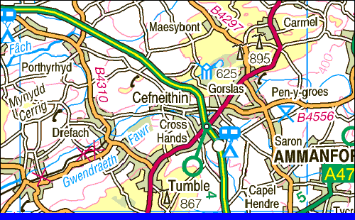
TO CROSS HANDS Situated just three miles from the end of the M4 motorway at Pont Abraham Services and on the A48 dual carriageway to Carmarthen, Cross Hands is near to the source of the Gwendraeth at Llyn Llech Owain lake and at the head of the Gwendraeth Valley which runs down to the sea at Kidwelly, some 15 miles away. On the site of the former drift coal mine, the other side of the dual carriageway from the old village is a large business and retail park, with many companies established there. A further business park has been prepared on the village side of the A48 but despite much interest, no companies are yet established there. The village itself, as a commercial centre, stretches from the roundabout to the old cross roads and beyond, along Carmarthen Road, Pontadulais Road and the road to Tumble. There are about 40 to 50 shops and businesses in Cross Hands village. Much of the railway line that served the collieries at Cross Hands remains visible today. The railway ran from Llanelli, along the upper slopes of the Gwendraeth Valley serving the Cynheidre Collery above Pontyberem andthe Mynydd Mawr Colliery at Tumble. It is known as the Myndd Mawr Railway to distinguish it from the railway from Burry Port through Pontyberem up to the Cwm Mawr at Lower Tumble, which is still operational. The Mynydd Mawr Railway ended at the deep mine at Cross Hands. From there a branch line ran to Gorslas. It is still visible today around the edge of Cross Hands Park. From the drift mine, a branch line ran to Penygroes, which remains as a footpath today. All
that is visible today of the drift mine at Cross Hands is the
building where the pit ponies were stabled on the roundabout.
The managers house is now a nightclub.
|